

Transcript
Somewhere in the sandstone cliffs of southern Jordan, there is a city that the world forgot for a thousand years. Not buried under ash, not swallowed by the sea, but simply... abandoned. The caravans stopped coming. The water channels silted up. The priests and merchants and gladiator crowds drifted away, and the rock-cut facades were left to the wind and the Bedouin goats. By the nineteenth century, the Christian West did not know it existed.
Petra sits in a basin of rose-coloured sandstone in what is now southern Jordan, ringed by mountains that drop into the great Arabah valley running south toward the Red Sea. The city is not built so much as carved: its temples, tombs, and theatres cut directly from the cliff face, their columns and pediments shaped from the living rock. That colour, a warm blush of pink and amber, is why later visitors called it the Rose City. But before any of that, before the carving began, people had been living in this landscape for an extraordinarily long time.
By around seven thousand years before the common era, early farming communities had already settled at Beidha, a Neolithic village just north of the Petra basin. In the Iron Age, between roughly twelve hundred and six hundred years before the common era, the area was occupied by the Edomites, a people who recognised immediately what the surrounding mountains offered: a natural reservoir of water, and a stopping point for merchants moving wines, olive oil, and timber across the desert. The trade logic of Petra was ancient long before the Nabataeans arrived.
The Nabataeans were a nomadic Arab people who moved through the Arabian Desert with their herds and, sometime in the fourth century before the common era, recognised in the Petra basin something no other group had fully exploited: the intersection of every major caravan route in the region. From Petra you could reach Gaza to the west, Damascus to the north, the Red Sea ports to the south, and the Persian Gulf routes to the east. Control Petra, and you taxed the world.
What made Nabataean dominance possible was not military force alone but an engineering achievement that still astonishes: they mastered water in a landscape that had almost none. Flash floods tore through the canyons seasonally, and the Nabataeans captured every drop, building dams, cisterns, and a network of ceramic-piped conduits cut into the canyon walls and rims. Archaeologist Philip Hammond, who worked at Petra for nearly four decades, described carved channels deep within the walls and ground that once fed the city from rock-cut systems on the canyon rim. The desert city became an artificial oasis.
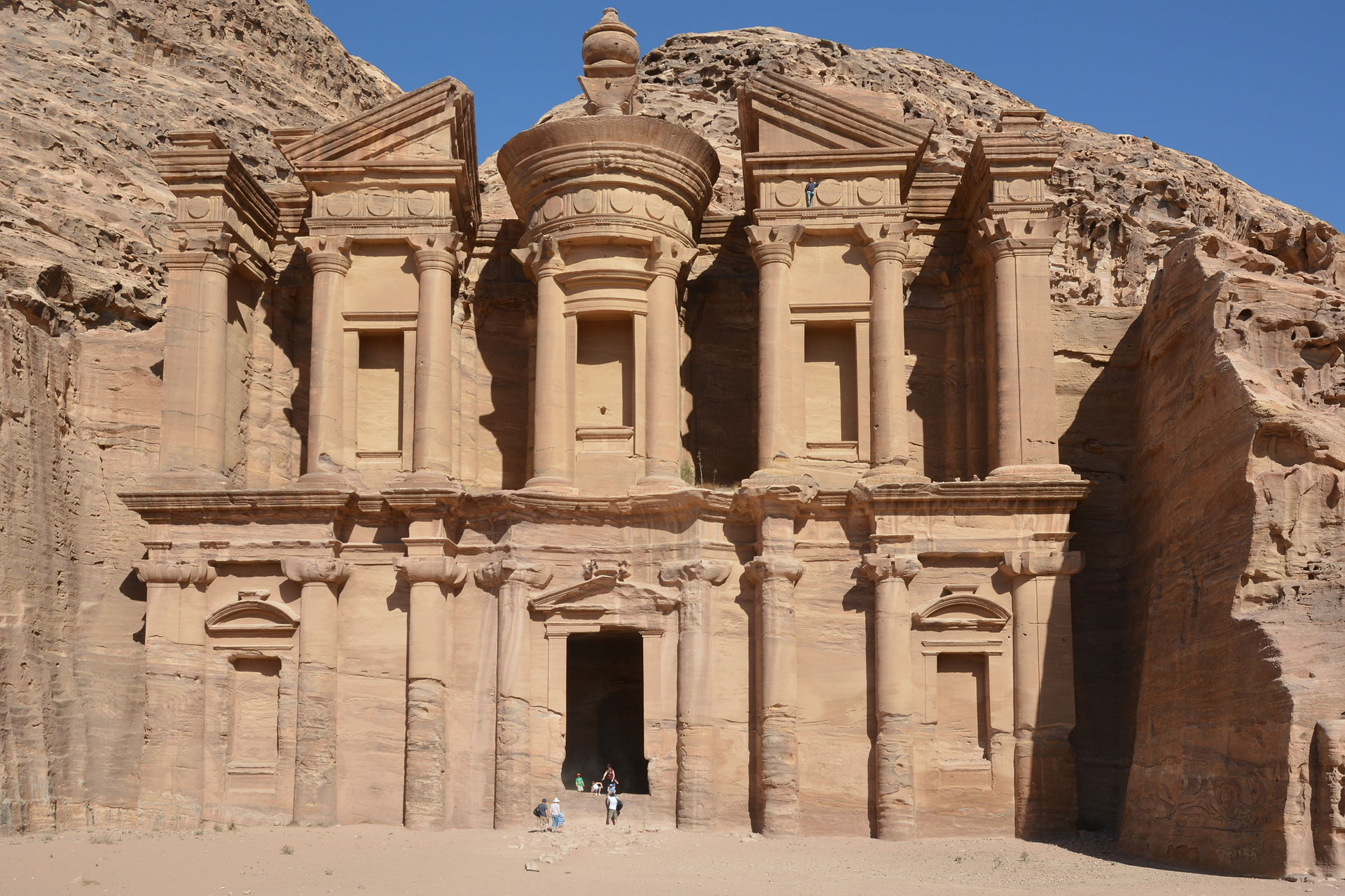
The Nabataeans called their city Raqemu, a word that likely meant something like "the decorated place" in their northern Arabian tongue. They worshipped a pantheon of Arab deities, chief among them Dushara, the principal male god, accompanied by three female counterparts: Al-Uzza, Allat, and Manat. One king, Obodas the First, was deified after his death in 85 before the common era, and the great Monastery, Petra's largest monument carved from the cliff face at forty-five metres tall and fifty metres wide, was dedicated to him as a god. The Nabataeans built their theology into the stone alongside their commerce.
Petra became the capital of the Nabataean Kingdom in the second century before the common era, and it was during the reign of King Aretas the Fourth, who ruled from around nine before the common era to forty of the common era, that the city reached its architectural peak. The Treasury, known in Arabic as Al-Khazneh, was almost certainly built during this era, possibly as Aretas's own mausoleum. It stands twenty-four metres wide and thirty-seven metres tall, its facade carved in the Hellenistic style of Alexandria, complete with a broken pediment, a central tholos tower, and sculpted figures including the twin gods Castor and Pollux at its base, protectors of travellers. The population at its height reached an estimated twenty thousand people.
To approach Petra in its flourishing was to enter through the Siq, a natural gorge split deep into the sandstone, in places barely three metres wide, its walls soaring overhead. The gorge served as both dramatic entrance and defensive advantage. When the crack of rock opened at the far end, the Treasury's carved facade appeared suddenly, overwhelming in scale and colour. Beyond it lay a theatre cut from the hillside capable of holding around eight thousand five hundred spectators, where audiences attended poetry readings and dramas, and where gladiatorial contests drew the largest crowds, though the mortality rate was heavy enough that no gladiator built lasting fame.
The city centre beyond the theatre opened into a colonnaded street, one of the few structures in Petra actually built rather than carved. Seventy-two columns lined each side after the Romans later widened it. At its heart lay a garden complex with a large swimming pool, an island pavilion, and a hydraulic system of considerable ingenuity. The sacred quarter at the street's end held two great temples: the Qasr al-Bint and the Temple of the Winged Lions, dedicated to Aretas the Fourth's reign. High above the city on Jebel Madbah mountain, an eight-hundred-step climb led to the High Place of Sacrifice, where libations were poured and goats were slaughtered annually in honour of Aaron, brother of Moses, whose tomb was held to be nearby.
Read full transcript (12 more paragraphs)
The Royal Tombs cut into the eastern cliff face represented the grandest of Nabataean funerary architecture. The Urn Tomb had a great colonnaded yard before its entrance and would later, in 446 of the common era, be converted into a Christian church. The Corinthian Tomb beside it echoed the Treasury's facade. The Palace Tomb, largest of the group, is believed to have served the kings themselves. And in 2016, archaeologists using satellite imaging discovered a previously unknown monumental platform to the south of the city centre, its beginnings tentatively dated to around 150 before the common era: a vast ceremonial structure second in size only to the Monastery, its purpose still unknown.
In 106 of the common era, the Roman general Aulus Cornelius Palma, then governor of Roman Syria, absorbed the Nabataean Kingdom into the Roman Empire without recorded military resistance. Rome renamed the province Arabia Petraea. The native dynasty ended. But the city itself did not immediately die. The Romans built a road through it, the Via Traiana Nova, connecting the Syrian border to the Red Sea, and the old Nabataean caravan routes found new Roman traffic. In 130, the emperor Hadrian visited personally and gave the city the honorific name Hadriani Petra Metropolis, stamped onto his coins, though his visit brought none of the construction boom it produced at nearby Jerash.
Rome's interest in Petra continued into the third century. An inscription to the god Liber Pater, favoured by the emperor Septimius Severus, was found in the temple precinct of the Qasr al-Bint, and Nabataean tombs yielded silver coins bearing his portrait. A later emperor, Elagabalus, declared Petra a Roman colony. But the structural logic of Petra's wealth was already being undermined. As sea-based trade routes through the Red Sea grew more efficient, the overland caravan traffic that had made Petra rich began to divert. The rival city of Palmyra, flourishing between around 130 and 270 of the common era, pulled much of the pre-Islamic Arab trade northward.
Then came the earthquake. In 363, a massive tremor destroyed a large portion of Petra's buildings and, more critically, crippled the water management system that had made the desert city liveable. The city never fully recovered. Christianity had arrived in Petra around 330, when the emperor Constantine the First issued his decree of tolerance ending the persecution of Christians across the empire. Petra became a bishopric. The Urn Tomb was consecrated as a church in 447. Byzantine churches were constructed across the city, and in one of them, excavated in the 1990s, archaeologists found a cache of a hundred and forty papyri containing contracts dated from the 530s to the 590s, confirming the city was still functioning, if diminished, into the sixth century.
The last written reference to Byzantine Petra comes from a text completed in the early seventh century, which mentions its bishop Athenogenes by name. Sometime before 687, even the bishopric was transferred elsewhere. Petra is not mentioned in any account of the Muslim conquest of the region in the seventh century, nor in any early Islamic records. It had already ceased to matter. A handful of nomads occupied the ruins, and the city carved from rose sandstone quietly disappeared from the world's awareness.
In the twelfth century, Crusader forces under King Baldwin the First of Jerusalem occupied the Petra region and built at least two fortresses in and around the site, including one on the summit of el-Habis at the city's heart. The Crusaders held the area, which they called Chateau de la Vallee de Moyse, until 1189. A Mamluk sultan, Baibars, one of the first rulers of the Mamluk dynasty in Egypt, visited the ruins toward the end of the thirteenth century as a curiosity. After that, European knowledge of Petra went dark entirely.
In 1812, a Swiss traveller named Johann Ludwig Burckhardt was making his way toward the Niger River when he heard stories of a dead city in the mountains of southern Jordan, said to hold the tomb of the Prophet Aaron. Burckhardt spoke fluent Arabic. He dressed as a local, brought a goat to sacrifice at Aaron's tomb as cover for his intentions, and entered the gorge. After a single day of exploring, he was convinced he had found the lost city. The Western world's knowledge of Petra resumed after a thousand years of silence.
Word spread quickly. The French artists Léon de Laborde and his companion Linant de Bellefonds made the first accurate drawings of the site in 1828. The Scottish painter David Roberts arrived in 1839 and returned home with sketches published in a large illustrated volume on the Holy Land and Arabia, bringing Petra's image to a wide British public. The American landscape painter Frederic Edwin Church visited in 1868, producing a canvas of the Treasury that became one of his most celebrated works. In December 1909, the first photographs of Petra appeared in the pages of National Geographic.
Formal archaeology came later still. In 1929, a four-person team, including British archaeologists Agnes Conway and George Horsfield alongside Palestinian scholar Tawfiq Canaan and the Danish researcher Ditlef Nielsen, conducted the first systematic excavation and survey of the site. In 1993, a cache of Greek scrolls from the Byzantine period was discovered in a church near the Temple of the Winged Lions. Ongoing excavations have since uncovered the garden complex, the colonnaded street, and the great platform south of the city, each find expanding what was already known to be one of the ancient world's most sophisticated urban environments.
The Bedul Bedouin, who had lived inside the caves and rock-cut structures of Petra for generations, were relocated by the Jordanian government in 1985 to the nearby settlement of Umm Sayhoun, prior to the UNESCO designation process that would follow. On the sixth of December that same year, Petra was designated a UNESCO World Heritage Site. In 2007, a global poll named it one of the New Seven Wonders of the World. The site now receives close to a million visitors a year, and that success has brought its own pressures: erosion from flooding, salt upwelling through the sandstone, and the wear of unsustainable tourist numbers have all placed the carved facades under threat.
In 1845, the British poet John William Burgon won Oxford University's Newdigate Prize for a poem simply called "Petra", and the line it left behind has outlasted almost everything else written about the city: "a rose-red city half as old as time." It is an exaggeration, of course. Petra is not half as old as time. But the phrase caught something true about what the place does to the imagination: it feels older than it should, deeper than its years, a city that was never entirely of the present even when it was alive.
What the Nabataeans built in the sandstone of southern Jordan was not just a trading post or a defensive stronghold, though it was both of those. It was proof that a nomadic people, moving with their herds through one of the world's harshest landscapes, could stop at the right place and transform it entirely: engineering water from rock, carving temples from cliff faces, routing the wealth of continents through a gorge barely wide enough for a loaded camel. Petra was abandoned, forgotten, and rediscovered, but the stone they carved has held. The rose-red facades are still there, and every year, close to a million people walk through the Siq to find them.
Image: Azurfrog, CC BY-SA 3.0 · AI-narrated · Drawn from Wikipedia · CC BY-SA 4.0